|
Introduction / The Island / Schooling Pharay School
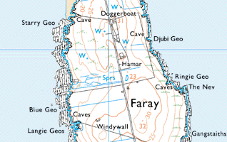
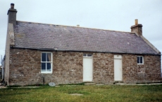
The school was built on one of the highest points on Pharay, between Hammar and Doggerboat. It is not actually shown on the map. Estimates were obtained in 1884, the tender for the building going to Westray. One of the masons, James Reid from Smittaldy was later to move to Holland in Pharay. Prior to that, the roof of the old building had got so bad that people were refusing to send their children to the school. The new building, which had a slate roof, was put up by the owners of the island and rented to the School Board. Children used to take peats to the school each morning for the fire. It was quite exposed with no dyke around it for shelter.
The building combined both a classroom and a schoolhouse for the teacher with a door through from one to the other. There would have been a mixed age group in the classroom ranging from five to fourteen when children left the school. School life was influenced considerably by the school’s situation and the seasons. The building was the best on the island and was maintained, following the last of the Pharay people leaving, as accommodation for those from Westray who stayed for the lambing. The roofs of the other houses all largely fell in over the years. | |||||||