|
Introduction / Houses Hammar
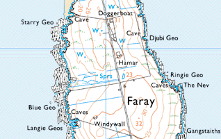
Hammar lies just in the north end of the island with Doggerboat, to the north and Lakequoy (indicated on the map but not named) to the south. Windywa is to the south of that. It lies on the east side of the road. While not shown on the map, the school lies between Hammar and Doggerboat on one of the highest points of the island. The tenant back at the time of the 1810 rental was James Gray but for the greater part of the 19th century Hammar is very much a house associated with the Drevers. The number of Drever households over the period of the published censuses varied between two or three into the 1890s. In 1841, David Drever was there with a separate household according to the
census for his son In 1851, son Thomas Drever formed a separate household and sons David Drever and James Drever formed separate households in 1861. David Drever continued to stay at Hammar until some time after the 1891 census. His son in law James Harcus was there in 1881 and 1891. The tenancy was subsequently taken over by John Seatter from Noup in Westray who came to Hammar around 1900. As for other houses, there was more frequency of change of tenant in the last 50 years of occupancy of the island. James Rendall and his family came from Westray in 1915 and John Leslie in 1938. Shortly thereafter, he took over the tenancies of Cott and Quoy while his brother Robert Leslie took over Hammar. Robert was the last tenant of Hammar before the last of the residents moved out of the island. | |||||