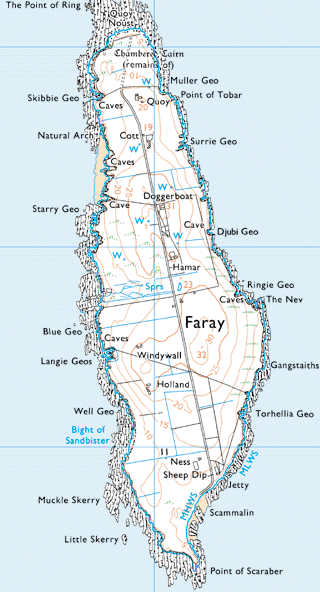
Home Contacts
Main Sections:
The Island
Houses
Families
Pharay Photos

Site Maps:
The Island
Houses
Families
Pharay Photos


Related Websites:
Fea
Gray


Other website
The Glasgow Orkney and Shetland Benevolent Society

Introduction

Pharay Photos

Click on the map hot spots or right hand menu, which includes some features not on the map. See also the gravestone photos and the view from the boat travelling north up the west side of the island as well as photos for the Pharay Holm and Rusk Holm

  From Ordnance Survey One-Inch Map of Great Britain:
  National Grid Seventh Series - Fully revised 1957

Ariel photos

Buildings
Quoy
Cott
Doggerboat
School
Hammar
Lakequoy
Windywa
Holland
Ness

Burial ground
Jetty

Geographical Features
Bight of Sandbister
Djubi Geo
Lavey Sound
Long Sand and Long Sandy Geo
Muckle Skerry
Natural arch
Point of Lakequoy
Point of Scaraber
Scammalin Bay


Printer Friendly Version Return to top of page