|
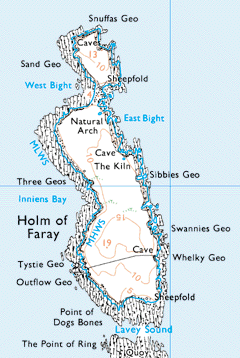
The Introduction / The Island / Geography / Pharay Holm Geos and Coastal Features of the Pharay HolmCrossing Lavey Sound from Pharay, the Point of Dogs Bones is in the south west of the Holm. The story of how it got its name goes back to an old ship wreck at this point.
On the west side of the Holm, there are some graves just to the south west of Outflow Geo. Nothing was known about these when the OS map makers were on the island around the 1880s. Tystie Geo is just to the north and then Duppies Geo (not on map) about a quarter of a mile from the south end and before coming to Inniens Bay. Three Geos is a small geo to the north of it and in the centre of the west coast of the Holm. Proceeding north leads to the West Bight and Sand Geo. The Holm is very narrow between the East and West Bights. There are a couple of natural arches and caves close to Snuffies Geo at the north end. Coming down the east side of the Holm, there is a sheepfold at the narrow before the East Bight. There is another cave to the south of the East Bight and the Kiln. Kilns are holes in the ground at the top of the cliff through which the sea can spray up when the weather is “coorse”. Geos going south down the east side are Sibbies Geo, Peat Geo (not shown but 100 yards to the south of Sibbies Geo), Swannies Geo (a quarter of a mile to the north of the south end) and Whelky Geo. | |||||