|
Introduction / The Island / Geography Pharay (Faray) Holm
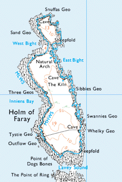
The Pharay Holm lies to the north end of Pharay and extends to some 100 acres. Unlike Pharay itself, the Holm has heather coverage and peat. There are numerous geos and other coastal features. It is separated from Pharay by Lavey Sound, which ebbs dry for three hours on a stream tide. In the past when the old run-rig system was in operation on Pharay, the Holm was common land where all the houses could tether their animals. Later the children would guard the crossing to ensure that animals did not come across to Pharay when it ebbed dry. It has been said that much courting went on while the young people were tending to the sheep. Due to the tides running through it, Lavey sound has claimed a number of lives. The trawler "Hope" went ashore on the south east of the Holm on 28th December 1908. | |||||