 | ||||||
|
Introduction / Pharay Photos Rusk Holm Photos
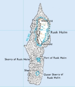
Rusk Holm is a small holm lying to the west of the south end of Pharay. See the larger scale map for its position in relation to Pharay, the Pharay Holm, Weather Ness in Westray and the Point of Fersness, Eday. Part of the Holm can just be see in an ariel photo that takes in Pharay, the Pharay Holm and Westray. Rusk Holm Photos: The holm has been used for grazing sheep. As for the Pharay Holm, seals breed on Rusk Holm. | |||||


