|
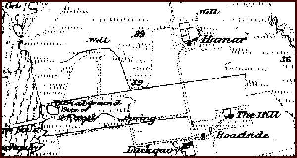
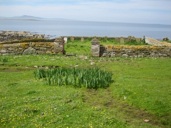
Introduction / The Island / Religion Burial GroundThe burial ground is by Kirk Noust and the site of a chapel. The comment has been made that there were lots of Drummonds there, which is perhaps not surprising as one of the early and long residing families on the island.
See the burial ground plan. From the gravestone transcriptions, one of the last burials is thought to have been that of Ann Drever, wife of William Wallace at the Ness, who died on 22nd October 1907. This was the day after giving birth to their fourth child. Subsequent burials would have been in the Old Kirkyard on Eday. Others interred include: Robert Burgar, Cott who drowned on 11th December 1895 when returning from taking the factor’s clerk to Westray. His daughter, Catherine Ann Burgar, who died four years earlier on 17th January 1892 is also there. She was nineteen and had married James Drever (son of David Drever and Mary Groat) from Hammar.
James Groat of Lakequoy who died on 11th November 1904, aged sixty five and his son John Groat, who had died on 16th April 1896 at the age of sixteen. They are in the south west corner. For those who died outside of Pharay, the problems of transportation meant that it was not always possibly for internment to be in the burial ground on the island. James Groat’s widow, Mary Drummond, died in Westray on 9th March 1922 at the age of seventy two. As the weather was rough, she couldn’t be brought back and was interred in the kirkyard at Pierowall. In 1925, mason Alex Costie from Westray came over and built a dyke around the burial ground, which had not been enclosed previously. The remains of the chapel were incorporated within the dyke. The Ordnance Survey map from about 1890 also indicates some graves at the south end of the Pharay Holm. | |||||||