|
Introduction / The Island / Geography / Pharay Pharay East SideAs the principal features of the island are its coastline, it is appropriate to look at the east and the west side of the island separately.
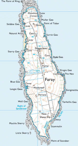
Quoy had a noust on Lavey Sound and there was also the remains of a chambered cairn to the north of the house. Muller Geo, about 100 yards east is described as having a shingle beach in the 1880s. The Point of Tobar is to the south, Tobar being a ledge on the shore. To the south of that is Surrie Geo where boats were hauled up. Ronaldsay Geo and Cleuds Geo (a deep geo not on the map) are between Surrie Geo and Djubi Geo. Cleuds Geo is just 260 yards north east of the school (not on map). Annie Rousay spoke of a teacher from the Eday North School being put ashore with some difficulty there. Djubi Geo is about 200 yards directly east of the school Ringie Geo, another deep geo, to the south is where yellow freestone used to be quarried. There are a number of caves on this side before coming to the Nev where fish were dried. The rocks of the Nev are black and scarfs (cormorants) sit on them. Gangstaiths is a small point of land that projects out into the sound, about 270 yards to the north of Torheilia Geo. They are about a third of a mile to the east of the buildings at Holland. The Jetty at Ware Geo was put on in 1935 near the Ness in the south end of the island. Scammalin is a low lying sandy beach from which ware used to be carried. The furthest point south is the Point of Scaraber.
| |||||