 | ||||||
|
Introduction / The Island / Geography / Pharay Pharay West Side
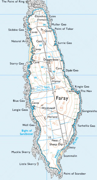
There are a larger number of caves and geos on the west side of the island compared to the east. Close by Blue Geo (not on map), north of Skibbie Geo, is what the OS map of the 1880s describes as the site of a broch although the name book used by the mapmakers somewhat confusingly gives the description “pictish fort”. Going south, Bercastle Geo, Broad Sandy Geo, Long Sandy Geo and Rammay Geo (all not on the adjacent map) come before Starry Geo. There was a crane at Rammy Geo at one time. A small bay, Feud Geo, is a little to the south of Starry Geo. Kirk Noust, the Geo of Lakequoy and Sheepright Geo are close together to the south of that although none of these are shown on the adjacent map. The burial ground and the site of a chapel are close to Kirk Noust. These features can be seen on the map on the burial ground and chapel pages. Blue Geo, the Castle (not on map) and Langie Geos are to the west of Windywa. There is a story of an opening at Small Langie Geo. One day a woman lost her rooster there. A day or two later when the family were sitting in Windywa, they heard it crowing. It seemed to come from beneath the fireplace. They lifted the hearthstone and low and behold it came out unharmed, presumably having followed a fissure from the geo. Well Geo is about 100 yards to the west of Holland. Brengeos (not on map) comprising three small geos is also close by. There are stacks of high rocks with grass on top that were used to conceal malt from the guagers. To the south is a fairly large bay, the Bight of Sandbister. Muckle Skerry and Little Skerry lie to the south and the Point of Scaraber is the most southerly point on the island. | |||||


